
Visitor Info Getting There With Etosha Map Gps Coordinates – Visitors can also use GPS or a mapping app to navigate from the airport to the B1 highway. The GPS coordinates for the Hosea Kutako International Airport are: -22.4877, 17.4629. It is important to note that while traveling on the B1 highway, visitors should obey the speed limit, as there are frequent police checkpoints along the road. Visitors should also be prepared for varying road conditions, as the B1 highway can be quite rural in some areas and may not be well-maintained in others.
While Okaukuejo has a superb waterhole that attracts an array of wildlife looking to quench their thirst, there are also other good waterholes close to Okaukuejo Camp – Aus, Homob, Okondeka and Olifantsbad waterholes all offer excellent wildlife sightings. Ombika waterhole is conveniently located en route from Anderson Gate to Okaukuejo Camp.
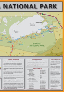
The kiosk sells beverages and snacks. Currently there are no braai facilities for campers, only flat bases to make fire. GPS coordinates for Olifantsrus, The guest farm is easily accessible with all vehicle types. It’s 9km along the D2710, a well-maintained gravel-road, which turns westwards off the main C38 tar road halfway between Outjo and Okaukuejo. Its GPS co-ordinates are S19.67507 E15.81307.
To the north, the conservancy is surrounded by the pulsating life of the communal areas of the Oshikoto, Oshana, Ohangwena and Omusati regions. This new Gondwana lodge gives guests the opportunity to combine the natural wonders of Etosha with the cultural vibrancy of the Aawambo people. You can also reserve your transfer to Etosha Safari Camp. Check the Etosha Safari Lodge map for directions.